
BROOKFIELD GARDEN VILLAGE What have the Romans ever done for us - (a tale of roads, digging and delays)

 | Kevin is Corporate Projects Manager at Broxbourne Borough Council. He is a former chartered surveyor with 48 years’ experience working for local government and quangos covering large scale regeneration projects including the Millenium Dome, Football club relocations, shopping developments, data centres, offices, etc. He is a member of the Eastern Branch of ACES and has written a number of times for ACES’ Terrier. He won an ACES Award for Excellence in 2025. Sousaphone player with the Hertfordshire Showband (the UKs only entrant in the Marching Band section of the World Music Contest in Kerkrade, Netherlands this coming July). |
Kevin wrote about Brookfield Riverside development in 2020 Winter Terrier, where he as ked “Madness or inspired intervention?” He concluded “The processes the councils have been through to date, with its advisors and development partner, will provide a robust platform for the partnership, and vision to develop into the full-blown project, with a massive acceleration expected over the next 12 months.” So here we are, inevitably meeting with unanticipated challenges along the way, outlined below. But Kevin does warn us that it is a complicated site. |
As the Monty Python discourse in the Life of Brian details - apart from medicine, irrigation, health, roads, cheese, education, baths and the Circus Maximus, what have the Romans ever done for us?
In respect of Broxbourne Borough Council and Hertfordshire County Councils (together “the councils”) proposals for Brookfield Garden Village (BGV) the focus fell on roads (although it also involves education and health, but at the moment not a lot of cheese), specifically Ermine Street, which, as a lot of readers will be aware, is a road that ran, and in some places still runs, from London to Lincoln and York.
English Heritage
Through Broxbourne the route, it seems, runs through the council owned Cheshunt Park and northwards through the planned Brookfield Garden Village (BGV) which is jointly owned by the councils. The route of the road was catered for in the original masterplan designs and considered during the local plan process and at Planning Committee stages. However, at the last knockings of the Planning Committee approval process, Historic England (HE), in considering some magnetronic surveys carried out by the councils, decided there was enough evidence to justify placing a Schedule Ancient Monument (SAM) order along the route of the road, but with a 50 metre buffer zone (along each side), as there were indications of the possibility of some sort of settlement at the northern end of the site. This zoning potentially wiped out at least 200 homes out of 1,250 planned and therefore rendering the whole project unviable.
As can be imagined, this left everyone a bit stunned and wondering why HE suddenly took this stance, especially as a number of years early the BBC (that is British Broadcasting Corporation not Broxbourne Borough Council!) Time Team had done an investigation on the road route a bit further south in Cheshunt Park which only made limited discoveries.
Within the planned Garden Village area there are already two other scheduled ancient monuments which are not being touched, mainly because they also lie in some Ancient Woodland (it’s a complicated site); during consultations HE wanted a 50-metre buffer zone around these as well but this was not accepted and the LPA dictated a 15-metre buffer zone, so make of that what you will.
So what did the councils do? The councils’ heritage consultants, Tetra Tech, immediately went into consultation with HE to try and delay the scheduling because once scheduled , in effect, that’s it, no right of appeal except when it reaches Secretary of State stage, where it may be possible for a political intervention.
After some negotiations it was agreed that the councils would carry out archaeological trenching across the whole of the BGV site and not just the area affected by Ermine Street. Apart from, that is - I said it was a complicated site - the landfill areas from previous gravel extraction.

A scheme of trial trenching was agreed and it covered approximately 5% of the site in a herring bone type fashion, but with a greater concentration in areas of concern. A quick glimpse at Google Earth reveals the extent of the trenching, with the A10 to the east of the site, and it looks like a lot more than 5%! The green swathe of trees in the middle contains the other two SAMs and the route of Ermine Street lies to the west of this, travelling north from a small copse of trees.
The results of the dig were not spectacular, the route of the road was reasonably clearly defined by the ditches on either side, but the surface of the road was not present in any great detail, having probably been disturbed over the years by ploughing and digging of drainage trenches.
A large horde of broken pottery was found, but nothing that would essentially prove that a settlement had existed (such as foundations, brickwork, other distinctive finds), and it was considered that it was more likely a small staging post travelling north out of London, as the site is considered to be roughly a day’s march for the Roman Legions from central London.
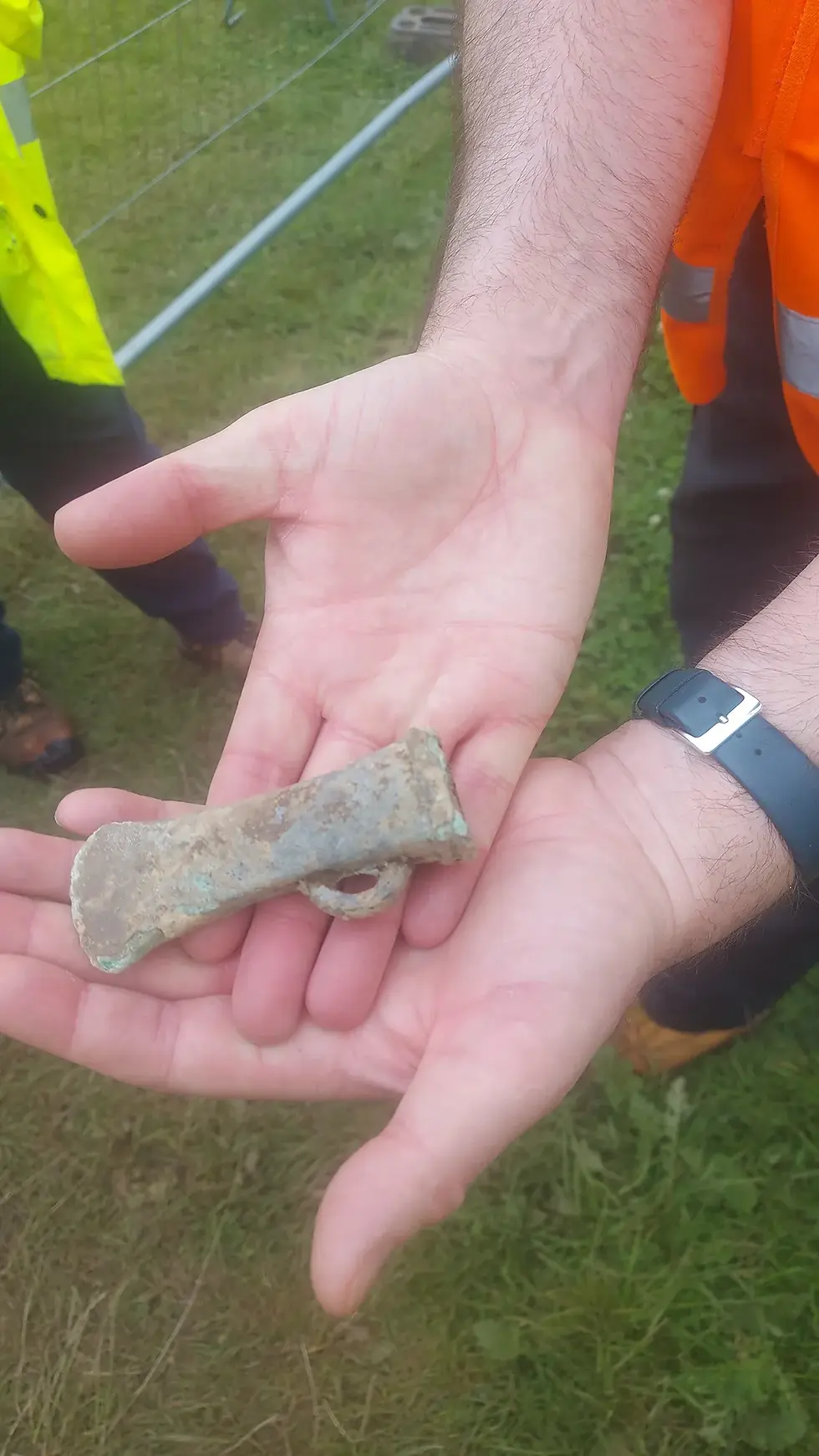
Across the remainder of the site there was again little of note apart from one solitary iron age axe head (shown in the image)
Planning and land matters
Following on from the results, a much smaller zoning area was agreed with HE and a redesign of the master plan meant that with a reference to the road as open space and slightly moving around of dwellings, coupled with small density increases, the original target of 1,250 homes could be maintained and still keeping within the overall Garden Village concept.

The revised masterplan (see image) shows the SAM of Ermine Street clearly visible to the west of the site.
An amended planning application was submitted and outline approval given on 27 August 2025 (almost two years after the original submission) - this time with no outstanding objections. However, the way was still not 100% clear - did I mention this was a complicated site?
A portion of the site was owned by local farmers, who had retained the land from the original sale to facilitate the overall project, and the councils were in an agreement with them over how the site, once planning permission was granted, would be marketed and values split.
With the changes to the overall scheme in the intervening years, from the agreement to the submission of planning application, the councils considered that the acquisition of the retained land would now provide a much cleaner proposal to the market.
Despite attempts by the councils to buy out the agreement, the farmers negotiated a private deal with another third party, and over the past 2-3 years, the councils have been in fresh negotiations with this party to reach a modernised version of the agreement, allowing for the changes in the proposed development (the original agreement was entered into in 2014) and a smoother way of bringing the site to the market, not forgetting the councils’ ambitions for a new town centre adjoining the Garden Village: Riverside. This agreement has now been successfully concluded and marketing of the land for the first two phases of housing land, amounting to 600 units, commenced in May 2026.
Relocations
To enable all of this, the councils have also had to facilitate the relocations of a local gypsy community, a council vehicle depot, statutory allotments, and a waste recycling centre, as well as coping with a high pressure gas/oil pipeline running through the site and two local streams, badgers, bats, newts, the likely requirement of offsite BNG units to enable the 10% increase, and making major layout changes to the adjacent council owned golf course to allow for the necessary roads infrastructure (did I mention this was a complicated site?).
Realising a vision
The councils are now close to being able to realise a vision that first came forward in 2001, as well as the marketing of the land for the first 600 units being underway; the detailed design for the initial required infrastructure has been completed, and is awaiting final approvals from relevant bodies.
The councils of course will also be affected by LGR while the project is in the infancy of implementation, and this will need to be factored into any agreements with prospective developers. Restricted budgets also mean an inability to implement the required upfront infrastructure works (despite numerous grant and loan applications to central government) which if available, would accelerate the overall programme by around 12 months (note: further applications still being made!).
So in answer to my original question, the Romans provided us with a delay of around two years, increased costs, and a vast amount of broken pottery, which the councils will have to store pending any further investigations that are required as the proposed development progresses, and an open space which cannot be disturbed in any way but will enhance the overall feel of the Garden Village (so it’s not all bad!).
In summation - they came, they saw, they built a road (said with my tongue firmly in my cheek) and the councils are coping with it 😊and the commencement of the marketing of the land is a significant step forward for the overall Brookfield Project.



Comments